Facebook and Google have launched new tools to gather data on population movements in an effort to fight the spread of the new coronavirus.
Facebook said in a statement it has created new “disease prevention maps” designed to help researchers identify areas where the virus COVID-19 might spread next.
The information is based on data from users of the social media service. But Facebook says the user data will be processed without any personal information being shared. Facebook said its data is designed to provide information about general movements in and around cities, but not the activities of single individuals.
One of the Facebook tools is called a “co-location map.” It aims to use data to predict the probability that people in one area will come in contact with people in another.
Another map is meant to measure the effectiveness of stay-at-home orders put in place by governments in many parts of the world. Data is collected in areas to see if people are staying near their homes or are also visiting other parts of the area. Such information is meant to help officials decide “whether preventive measures are headed in the right direction,” Facebook said.

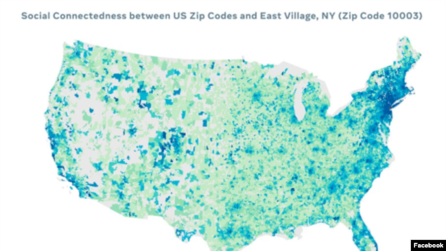
This map created by Facebook shows how connected parts of the United States are to the East Village area of New York City. The social media company says this data is provided to medical professionals and government officials to help them predict the likel
A third tool creates maps that show Facebook friendships across states and countries. The data can map a percentage of “social connectedness” in specific areas. The company said this data is provided to medical professionals to help them predict the likelihood of disease spread. It can also help officials learn how social ties can help communities fight and recover from the crisis.
The data is shared on a daily basis with local officials and nonprofit organizations across the world. The new maps are part of Facebook’s Data for Good program, which the company says attempts to use its huge supply of data to address important humanitarian issues.
In addition to the maps, Facebook announced it was partnering with university researchers to seek health information from some users willing to share it. The program is part of a research project created by America’s Carnegie Mellon University.
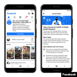
Beginning this week, some U.S. Facebook users will see a link at the top of their News Feed they can follow if they would like to take part in a survey about their personal health situation.
Researchers hope to use the survey data to create “heat maps” of self-reported coronavirus symptoms. The information could also help officials predict where medical resources will be needed.

This image shows a sample of what some Facebook users will see on their News Feed if they are invited to take part in a COVID-19 public research study. (Facebook)
Facebook promised it had taken steps to protect the privacy of those taking the survey. The company said it would not share the personal identities of its users with researchers from Carnegie Mellon. It added that the researchers will also not share individual survey answers with Facebook. If results are successful, Facebook says it will make similar surveys available to users in other parts of the world.
Google mobility reports
Google also recently announced a similar data gathering program, which creates “community mobility reports” for more than 100 nations. Google said the project does not involve use of personally identifiable information, such as an individual’s location, contacts or movement.
Google has long collected data for its Maps app to show how movements of people affect how busy different businesses are throughout the day. Public health officials have requested such data now to help fight the worldwide coronavirus crisis.

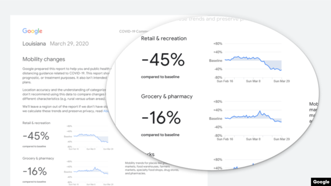
This example of one of Google’s Community Mobility Reports for movements of people in the U.S. state of Louisiana. (Google)
The reports – which are published online - provide information on the movements of people to several places in the community. These include trips to stores, recreation areas, parks, transportation centers, workplaces and homes. The reports show percentage increases or decreases in visits to those places.
Google said it hopes the information on the most and least visited places can help officials decide on future policies and resources aimed at fighting the virus.
Words in This Story
location – n. a place or position
survey – n. an examination of people’s opinions or behavior made by asking people questions
symptom – n. a physical feeling or problem that shows that someone has a particular illness
app – n. a program for a smartphone or other device that performs a special function
recreation – n. activities people do for enjoyment when they are not working